DCVoCamp2017
Contents
1. General[edit]
VoCamps are hands-on, working meetings where teams can spend some dedicated time creating lightweight vocabularies/ontologies for project use including publication on Semantic Web. The emphasis is not to attempt to create the ultimate ontology in a particular domain, but to create integrated vocabularies with lightweight semantics supported by conceptual models that are good enough for people to start using them as published data on the Web. We seek clarified agreement & reduced ambiguities/ conflicts on topics such as from the geospatial and earth science as well as other research phenomena that can be formally represented in: Constrained, engineered models to support understanding, reasoning & data interoperability and/or Creation of conceptual models and general patterns that provide a common framework to generate ontologies that are consistent and can support interoperability.
We like data-grounded work since: Much of the utility of research ontologies will likely come from their ability to relate geospatial and other research data to other kinds of information. The strategy of the session is to follow a "paper first, laptops second" format, where the modelling is done initially on paper and only later committed to formalization as ontology design patterns or ODPs.
For more see an overview of VoCamp methods and for an introduction to ontology design patterns and development methods see the briefing from prior DCVocamps or Ontology modeling with domain experts: The GeoVoCamp experience or Gary Berg-Cross's intro to GeoVocamps and overview of methods. For a slide overview of ODPs see Valentina Presutti's introduction and for an example of an ODP see A geo-ontology design pattern for semantic trajectories by Yingjie Hu et al
2 Where, When and How[edit]
2.1 Where[edit]
The workshop will take place at the Stewart Lee Udall bldg Department of the Interior 1849 C Street, N.W. Washington DC 20240
We will be submitting a list of planned attendees to the DOI so the guards out front should have you on an expected list. Our contact point at DOI is William Lukas who is in Rooms 6641 and his tele # is 202-208-4457.
We will start the meeting at the OS-OCIO Magnolia Conference Room 7013 MIB (this is on the top or 7th floor). We will be using this as our main Conference Room before breaking into work groups later in the day. Breakout sessions will include the main room (big enough for 2) and also :
- Sassafras room - 7148
- Conf room 6641
- Kiowa Room (basement level by the cafeteria)
- MIB 1548 (1st floor, a bit harder to find and only available on the 30th if needed)
The DOI building is accessible via Metro. We will be working with the local staff (a USGS representative) to identify parking options.
2.2 When[edit]
Our preliminary organization for the DC VoCamp 2017 workshop is complete.
This workshop will serve as follow-up to previous DC & SOCoP workshops/VoCamps in which a number of vocabularies, conceptual models and ontology design patterns have been crated, published and used.
This year's VoCamp will take place at DOI as noted above starting on Tuesday, Nov. 28th at 9 am and concluding at 2:30 (approximately) Thursday. Nov. 30th.
2.3 How[edit]
As in prior years we will meet the first morning as a group for short briefings on logistics, process and proposed topics. This will allow self organization into breakouts around 3 -4 Work Groups. Ideally these will be made up of domain experts, group facilitators and people with semantic/ontological experience. Since we expect 1 or more remote presentations, as in the past, the USGS has provided some remote access for these as part of the first morning sessions or at other general session times which are usually brief backs on status at the end of the day. Details on remote access are below.
Individual topic groups may choose to have remote access for part of their meeting and we often have a distinguished researcher as a speaker to the whole on the 2nd or 3rd day as appropriate.
VoCamp Workshop Remote Access Info[edit]
E. Lynn Usery has invited us to join a meeting on the Web, using WebEx USGS
Date: Every day, from Tuesday, November 28, 2017, to Wednesday, November 29, 2017 Time: 8:00 am, Eastern Standard Time (New York, GMT-05:00) Meeting number: 716 530 951 Meeting password: (This meeting does not require a password.)
People can click the link below to see more information, or to join the meeting.
Although no login account is required to use Webex to attend a meeting, you will need to supply your name, email address, and a meeting password (if provided) to join the meeting.
When it is time to attend the meeting, please visit this link: https://usgs.webex.com/usgs/j.php?MTID=m99b227309e69f6302bf55bf08730dca2
Teleconference: 1-866-687-7995; Passcode: 3591681#
- Please* check and prepare your computer a day or two
in advance of the meeting as follows:
- Start your web browser
- Visit http://usgs.webex.com
- Select Setup / Meeting manager (left side of page)
For Help with WebEx - WebEx setup help: 1-866-229-3239 - Info: https://usgs.webex.com/, click USGS Help (at left) - USGS account questions: gs_help_webinar@usgs.gov
To contact E. Lynn Usery, call 1-573-308-3837 or send a message to this address: usery@usgs.gov
Tools for the Vocamp: There are many options and tools are an open choice depending on people's experience and interests. Charler Vardemann has set up a GitHub to save and manage VoCamp products. We expect and update brief on this as part of the orientation sessions. If groups choose, they can store their work in a Github repository under the Vocamp organization. Google Docs and various pads have also been used to capture group work and thoughts. We have found that the yEd Graph Editor is useful for concept mapping. The Protege tool is helpful for creating OWL formalization from the concept maps. The Data Semantics Laboratory has created an experimental tool for creating concept maps directly in Protege called OWLAx that assists in axiomatization using the concept map as a basis.
3 What Topics[edit]
Currently 4 topic areas with varying degrees of detail have been proposed and teams are forming:
Terrain feature extraction for search and rescue[edit]
The goal for this work group is to not to initially design a new ontology pattern, but to develop a case study that highlights the utility of existing terrain ontologies and terrain mapping and feature extraction tools. The group has decided to use the context of a search and rescue mission, which together present a compelling case for correctly interpreting natural language expressions about terrain. As part of this work we will also discuss how to develop a terrain feature extraction software library based on existing work on feature extraction and terrain ontologies. Since feature extraction is quite complex, only features that can be reliably mapped will be used to determine what types of features will be focused on while developing the controlled vocabulary and, therefore, the scenario(s) for the case study. This link provides a draft visualization of geographic decisions that may have to made during a flooding scenario
As a work plan we propose these tentative steps (the latter of which may follow the VoCamp sessions):
- Decide types of terrain features that may be resolved by the semantic queries.
- Decide on the types of terrain features and properties that may be extracted from DEMs, and if needed from ancillary data.
- Based on steps 1 & 2, design possible queries that can be supported for the case study.
- Develop a GIS database for the case study.
- Identify how to specialize ontologies to support the semantic queries.
- Encode new axioms using an ontology language (OWL).
- Identify methods for feature extraction, and extract features for the study area.
- Create an ontology with features extracted and annotated with semantic labels based on ontology classes and properties.
- Implement a SPARQL querying system to query and map features
Hazards and Infrastructure[edit]
This group will work toward the objective of designing an ontology pattern or ontology modules of one or ore topics related to hazards (which have been modeled as patterns and infrastructure which has been has open data and vocabularies in HIFLD (homeland Infrastructure Foundation Level data). Possible subtopics for discussion include the following:
- The resolution of nomenclature -things as diverse as spill events, compensation, mitigation plans, regions, boundaries, toxic types...
- What type of competency questions are relevant? For example:
- What object (person, organization, facilities, equipment etc.) is exposed to a hazard?
- To which hazard is exposed an object (person, organization, equipment etc.)?
- Which hazardous events are associated with a hazardous situation?
- What is the cause of a hazardous event?
- What is the consequence of a hazardous event?
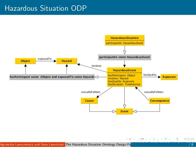
- What is the value of exposure of an object being exposed to a hazard? (based on The Hazardous Situation Ontology Design Pattern by Agnieszka Lawrynowicz and Ilona Lawniczak ( Poznan University of Technology, Poland )
- Uncertainty vs risk,
- One basic distinction is that situations of risk, are ones in which numerical probabilities can be determined, while situations of uncertainty, are ones in which they cannot.
- Resilience vs resiliency, and recovery and reconstruction; see for example Opportunities to Enhance the Nation’s Resilience to Climate Change
- What is meant by infrastructure,
- Infrastructure is the basic physical and organizational structure needed for the operation of various necessary applications so that they can function on top of this structure. In SE terms it is a system existing of interconnected elements organized to achieve one or more stated purposes.
- A data infrastructure is a digital infrastructure promoting data sharing and consumption. Similarly to other infrastructures, it is a structure needed for the operation of a society as well as the services and facilities necessary for an economy to function, the data economy in this case.
- The role of terrain: implications of being 'downslope' or 'downstream'
- Routing and navigation
- The role of local/non-expert participation
Drones and Drone Data:[edit]
Small Unmanned Aircraft Systems are rapidly becoming a tool of the trade for environmental scientists, along with many other commercial industries. Scientific data, however, requires strict data qualification yet there are currently no commonly acknowledged best practices regarding; schema, ontologies, and formats for either the metadata or the data. This is largely due to the nascent state of the field but also in part due to the new concepts sUAS use involves (such as new aircraft descriptions, sensor mountings, flight plan descriptions, and calibration procedures). There are many existing fields that can be learnt from (manned aircraft, sensor webs, underwater gliders, satellites,...) but the community needs to have a conversation on what should be adopted, what can be adapted, and what perhaps needs to be newly created.
Carrying out such conversations will ensure sUAS data is made FAIR as soon as possible, lower the barrier to entry for new users, and enable developers to build the data capture and analytics tools that are urgently needed. We propose here to work though an example sUAS data workflow from science hypothesis, through sensor/UAS selection and implementation, flight planning, flight preparation and execution, data collection, post processing, and data archive and distribution. At each stage we will identify what (meta)data should be captured, and consequently which possible semantic web technologies generally and ontologies specifically might applicable. This should result in a prototype 'best practice ontologies for sUAS data' document and identify where there are missing holes for what is needed and suggested solutions for such.
Chem Research[edit]
This will be a review of missing chemical concepts relative to needs for metadata and classification in chemical data sources and primary data reporting. We'll bring some examples where improved and accessible terminology is needed and compare this to existing authoritative vocabulary sources such as the IUPAC Gold Book. Work will involve NER dictionaries for chemical health & safety, and Gold Book term analysis. Chemical terminology supporting chemical safety description would be one application we can review.
4 Working Schedule[edit]
4.1 Day 1 Tuesday Nov. 28th[edit]
- 9:00 - 9:30 Introductions, Welcome, Logistics & Schedule Overview –DOI
Main room OS-OCIO Magnolia Conference Room 7013 MIB Note - Morning session includes an adobe connect virtual meeting
- 9:30 - 9:40 Pascal Hitzler will brief the group on 1st U.S. Semantic Technologies Symposium planned for March 1-2
- 9:40 – 10:00 Workshop Vision, Strategy & methods, tools... - Gary Berg-Cross and others
- 10:00 -11:00 Working Topics (Presented by Topic Leaders)
11:00- 11:15 Break
- 11:15 – 12:15 Group organization and introductions - setting goals and process
                     Breakout Rooms
 12:15 – 1:30  Lunch
- 1:30 – 4:00 Resume topic breakout meetings
- 4:00-5:30 Group Reports to the Whole – Magnolia Conference Room as a virtual meeting
- Post 5:30 PM – Groups may make arrangements for dinner on their own
Day 2: Wednesday Nov. 29th[edit]
- 9:00~9:15 Updates, Q & A etc. (schedule etc.) Main room
- 9:15- 9:45 Presentation on Formalizing things Torsten Hahmann
- 9:45-10:45 Group Work on Concepts, Vocabulary and Model (Breakout Rooms)
~ 10:45 -11 Break
- 11:00-12:15 Group Work on Draft Models (Breakout Rooms)
- 12:15 -1:15 Lunch and Networking – on your own
- 1:15- 2:45 Work Groups – draft final conceptual model (Breakout Rooms)
- 2:45- 3:15 Work Groups identify data to test model & Prepare initial formalizations
3:15-3:30 Break 3:30-4:30 Prepare Brief Back Report (Breakout Rooms)
- 4:30-5:30 Interim Group reports and discussion Main Room (Broadcast as Virtual Meeting)
- Dinner as organized by group interest
Day 3 Thursday Nov. 30[edit]
- 9:00-9:15 Updates, Q & A etc. (schedule, GiTHub effort etc.) Main Meeting Room
- 9:15-10:45 Work Groups Firming up products and alignments (Breakout Rooms)
10:45-11:00 Break
- 11:00-12:00 Prepare group reports and plans for follow up (Breakout Rooms)
12:00 -1:00 Lunch and Networking - On your Own
- 1:00 ~ 2:30 Group reports & Wrap up (Main Room) We expect to end around 2:30 pm to allow people to travel as needed
5 Organizers[edit]
- Gary Berg-Cross (Ontolog and RDA) (general & local coordinator)
- Dalia Varanka (Center of Excellence for Geospatial Information Science USGS)
- Thomas Dabolt (Geospatial Information Officer, US Department of the Interior)
- E. Lynn Usery (Center of Excellence for Geospatial Information Science USGS)
- Charles F. Vardeman (University of Notre Dame)
- Torsten Hahmann (University of Maine)
- Gaurav Sinha (Ohio University)
- Leah McEwen (Cornell University)
- Kathleen E Stewart (University of Maryland)
6 "Registered" to Participate[edit]
- Gary Berg-Cross (Ontolog and RDA) (general & local coordinator)
- Dalia Varanka (Center of Excellence for Geospatial Information Science USGS)
- Thomas Dabolt (Geospatial Information Officer, US Department of the Interior)
- Lynn Usery (Center of Excellence for Geospatial Information Science USGS)
- Charles F. Vardeman (University of Notre Dame)
- Samantha Arundel (USGS)
- Gaurav Sinha (Ohio University)
- Leah McEwen (Cornell University)
- Leonid Zaslavsky, PubChem, NCBI/NLM/NIH
- Jeff Zhang, PubChem, NCBI/NLM/NIH
- Kamruzzaman Sarker (Wright State)
- Peter Linstrom, Office of Data and Informatics, NIST
- Qingliang (Leon) Li (PubChem, NCBI/NLM/NIH)
- Evan Bolton, PubChem (NCBI/NLM/NIH)
- Donald R Burgess Jr. (NIST)
- Janet Wyngaard (University of Notre Dame)
- Lindsay Barbieri (UVM)
- Andrea Thomer (University of Michigan)
- George Percivall (OGC)
- Josip Adams (USGS)
- Patrick Stingley (CTO, BLM)
- Martijn Rasser (Director of Analysis at Kyndi)
- Kathleen E Stewart (UMD) Nov. 28th and remotely other times.
- Maria Stoica (University of Colorado, Boulder)
- Don Burgess (NIST)
- Mikhail (Misha) V. Sogonov (National Agricultural Library)
7 Not sure if I can attend, but interested[edit]
- Cogan Shimizu
- add here
8 Would like to participate remotely[edit]
- Torsten Hahmann (University of Maine)
- Nancy Wiegand (U of Wisconsin)
- Boleslo E. Romero (UCSB)
- add here
and contact us on details.
9 Directions to DOI[edit]
U.S. Department of the Interior Interior Museum 1849 C Street, NW Washington, DC 20240
Accessibility: An accessible entrance is located at the E Street entrance of the Stewart Lee Udall Department of the Interior Building.
Security Procedures: All adults are required to present a photo ID to enter the Stewart Lee Udall Department of the Interior Building. All visitors will be subject to security screenings, including bag and parcel checks. We will create a list of expected attendees and give them to the security desk.
Parking and Transportation:[edit]
By Metro
Take the 18th Street exit at the Farragut West Metro Station and walk south towards Constitution Avenue. There are 2 entrances and the one on E street is closest to Meteo. The listed entrance to the Stewart Lee Udall Interior Building is 6 blocks south on D Street between 18th and 19th. There is also a D st. entrance between 18th and 19th. Metro is probably best for travel from the area, but parking is basically street or local garages as there is no public parking at Main Interior. There are a number of Public parking garages in proximity to DOI. They are located on New York and Pennsylvania Avenues and 17th and 18th Streets. but they are a bit pricey, as you'd expect. Street parking has time limits and thus can also be pricey.
Driving Directions: From the North Take either 95 or 295 south to the Capitol Beltway, Route 495 Take 495 west towards Northern Virginia. Take exit 30, Georgia Avenue/29 south Proceed about 2 miles to 16th Street south. 16th Street veers to the right at this large intersection. Go approximately 10 miles to I Street, turn right. At the 4th light, turn left onto 19th Street. The entrance to the Main Interior Building is 6 blocks south on C Street between 18th and 19th.
From the South Take 395 North to Washington Boulevard/Memorial Bridge/Pentagon/Arlington Cemetery. Move to left lane. Cross Memorial Bridge in the center lane. At the Lincoln Memorial bear left and follow the road to the left on Henry Bacon Avenue until it ends at Constitution Avenue. Make a right on Constitution. Turn left onto 18th Street. The entrance to the Main Interior Building is 1 block north on C Street between 18th and 19th.
From Northern Virginia Take I-66 into Washington, staying in center lane to arrive at Constitution Ave. Turn left onto 18th Street. The entrance to the Main Interior Building is 1 block north on C Street between 18th and 19th.
Metro is probably best for travel from the area, but parking is basically street or local garages as there is no public parking at Main Interior. There are a number of garages in proximity to DOI, but they are a bit pricey, as you'd expect. Street parking has time limits and thus can also be pricey.
From Western Maryland Take 270 South to 495 West toward Northern Virginia. After crossing American Legion Bridge, take the next exit to the George Washington Parkway. You will cross the Theodore Roosevelt Bridge and end up on Constitution Avenue. Turn left on 18th Street. The entrance to the Main Interior Building is 1 block north on C Street between 18th and 19th.
10 Local Accommodations & Arrangements[edit]
DOI HQ has a number of nice features we can enjoy including:
Interior Museum[edit]
https://www.doi.gov/interiormuseum
Interior Mural Tour[edit]
https://www.doi.gov/interiormuseum/Tours
Welcome to the Neighborhood[edit]
This is a large document (pdf) with a lot of history and useful contact information about Interior. https://www.doi.gov/sites/doi.opengov.ibmcloud.com/files/uploads/OFAS-Welcome-to-the-Neighborhood.pdf
Dinning/Places to Eat[edit]
There are many options but lunch/breakfast is available t the Bison Bistro, located in the basement of the Interior Building. It is open to the public Monday through Friday from 7:30 a.m. to 2:30 p.m.
For dinner there are many restaurants located at Pennsylvania Avenue and 18th Street NW.
Taberna del Alabardero Washington D.C 1776 I St NW, 812 18th St NW, Washington DC, DC 20006-3700
- 127 of 2,834 Restaurants in DC
DE-LI-CIO-SO as you would say in spanish. For me it was authentic spanish food. The serrano jam and pork were our favorite appetizers. Entree? PAELLA!!!! With lobster, crab and mussels. Really really really good!
Washington D.C. Hotels near DOI[edit]
- Courtyard Washington, DC/Foggy Bottom
515 20th St NW Washington, DC 20006 (202) 296-5700 http://bit.ly/1TDfVNa (This hotel has rooms at the Federal Government/Military rate)
- Hotel Hive
- 5 of 142 Hotels in Washington DC
2224 F St NW, Washington DC, DC 20037-2728 (202) 849-8499 http://www.hotelhive.com/?utm_source=tripadvisor&utm_medium=businesslisting
- Morrison-Clark Historic Inn & Restaurant
1011 L St NW, Washington DC, DC 20001 (202) 898-1200 Hotel website A a boutique style hotel with a small bar and lobby area. It is a bit farther away but some deals make it relatively affordable. ( 2017 Room Prices from $160)
- 52 of 142 Hotels in Washington DC
- State Plaza Hotel ~$210/night
2117 E St NW Washington, DC 20037 (202) 861-8200 http://www.stateplaza.com/1011 L St NW, Washington DC, DC 20001 (202) 898-1200 Hotel website
- Club Quarters Hotel in Washington, D.C.
839 17th St NW Washington, DC 20006 (202) 463-6400 http://bit.ly/1Tznx3w
- AKA White House
1710 H St NW Washington, DC 20006 (202) 904-2500 http://bit.ly/wI269k
Neighboring Cultural Attractions include[edit]
Neighbors to the President Consortium which includes a local map and some historical/cultural sites.